
|
Features
|
|
|
|
Books
|
|
|
|
Fun & Games
|
|
|
|
Contact Us
|
|
|
John's Journal... Entry 241, Day 2
SPACE-AGE GOBBLERS WITH DON TAYLOR
Be Lost No More
 Editor's
Note: Global Positioning Systems (GPS) is a system of satellites that
circle the earth and give off signals. Each GPS satellite transmits its
precise location (position and elevation) and the start time of the transmission.
A GPS receiver acquires the signal and then measures the interval between
transmission and receipt of the signal to determine the distance between
the receiver and the satellite-a process called ranging. Once the receiver
has computed range for at least three satellites, the receiver's location
on the surface of the earth can be determined. Each satellite transmits
two types of data, almanac and ephemeris. Almanac data, general information
on the location and health of each satellite on the constellation, can
be collected from any satellite.
Editor's
Note: Global Positioning Systems (GPS) is a system of satellites that
circle the earth and give off signals. Each GPS satellite transmits its
precise location (position and elevation) and the start time of the transmission.
A GPS receiver acquires the signal and then measures the interval between
transmission and receipt of the signal to determine the distance between
the receiver and the satellite-a process called ranging. Once the receiver
has computed range for at least three satellites, the receiver's location
on the surface of the earth can be determined. Each satellite transmits
two types of data, almanac and ephemeris. Almanac data, general information
on the location and health of each satellite on the constellation, can
be collected from any satellite.
 A
receiver with a current almanac in its memory knows where in the sky to
look for satellites, given its last known position and the time of day.
Ephemeris data is the precise satellite positioning information that is
used for ranging. Each satellite transmits its own ephemeris data. Both
almanac and ephemeris data are required for a GPS receiver to locate and
acquire satellites quickly and compute your position. GPS produces accuracies
of about 27 yards or better, bringing you within visual range of a destination
or a target. Most GPS receivers allow you to log waypoints, either by
number or name, which remain in its memory until you either delete it
or change it. Regardless of your distance from a waypoint, the computer
can calculate the direction you need to travel and the distance from it.
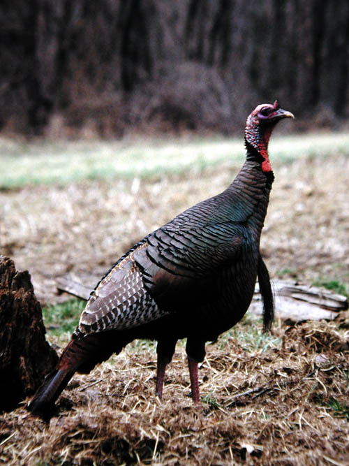
This week, Don Taylor, a longtime turkey hunter from Alabama, shares the
experiences he's had hunting with his GPS receiver.
A
receiver with a current almanac in its memory knows where in the sky to
look for satellites, given its last known position and the time of day.
Ephemeris data is the precise satellite positioning information that is
used for ranging. Each satellite transmits its own ephemeris data. Both
almanac and ephemeris data are required for a GPS receiver to locate and
acquire satellites quickly and compute your position. GPS produces accuracies
of about 27 yards or better, bringing you within visual range of a destination
or a target. Most GPS receivers allow you to log waypoints, either by
number or name, which remain in its memory until you either delete it
or change it. Regardless of your distance from a waypoint, the computer
can calculate the direction you need to travel and the distance from it.
This week, Don Taylor, a longtime turkey hunter from Alabama, shares the
experiences he's had hunting with his GPS receiver.
 Until
I acquired my first GPS receiver, I got lost about three times every turkey
season. Although I considered myself a good woodsman, I hunted turkeys
in several states each year, rarely hunting the same place twice. When
my host dropped me off at my hunting location before daylight, he usually
told me, "You can hear the bird gobble from here. We'll pick you up about
11:00 a.m." Having a compass didn't help me if I didn't know my location,
which way the roads ran or where I needed to go. But when and if I do
hear a turkey gobble, I'll go after him. I'll often have to reposition
myself three or four times or perhaps even hunt for a bird that doesn't
gobble.
Until
I acquired my first GPS receiver, I got lost about three times every turkey
season. Although I considered myself a good woodsman, I hunted turkeys
in several states each year, rarely hunting the same place twice. When
my host dropped me off at my hunting location before daylight, he usually
told me, "You can hear the bird gobble from here. We'll pick you up about
11:00 a.m." Having a compass didn't help me if I didn't know my location,
which way the roads ran or where I needed to go. But when and if I do
hear a turkey gobble, I'll go after him. I'll often have to reposition
myself three or four times or perhaps even hunt for a bird that doesn't
gobble.
 By
10:00 a.m., I can't find the road where my host dropped me and may spend
much of my hunting time trying to locate my pick-up point. However, since
I've used a GPS receiver, I don't get lost. When I climb out of my vehicle
in the morning, I locate my position on my GPS, and I store that position
as a waypoint in the receiver. When I get ready to come out of the woods,
I simply pull up the waypoint and hit the "Navigate" button. The GPS receiver
informs me of the distance to the car by the shortest route, and an arrow
points to the direction I need to walk. As I move toward the car, the
GPS receiver tells me how long walking to the car will take me at that
speed.
By
10:00 a.m., I can't find the road where my host dropped me and may spend
much of my hunting time trying to locate my pick-up point. However, since
I've used a GPS receiver, I don't get lost. When I climb out of my vehicle
in the morning, I locate my position on my GPS, and I store that position
as a waypoint in the receiver. When I get ready to come out of the woods,
I simply pull up the waypoint and hit the "Navigate" button. The GPS receiver
informs me of the distance to the car by the shortest route, and an arrow
points to the direction I need to walk. As I move toward the car, the
GPS receiver tells me how long walking to the car will take me at that
speed.
TOMORROW: HUNT NON-PRESSURED GOBBLERS AND CREATE A HUNTING PLAN USING YOUR GPS
Check back each day this week for more about SPACE-AGE GOBBLERS WITH DON TAYLOR ...
Day 1 - GPSing Albert
Day 2 - Be Lost No More
Day 3 - Hunt Non-Pressured Gobblers And Create
A Hunting Plan Using Your GPS
Day 4 - The Slue-Foot Gobbler
Day 5 - Give A Turkey To A Friend